The assertion that the Amazon only became urbanized after Europeans invaded the region in the 15th century is part of an increasingly outdated imaginary. Recent discoveries in Ecuador, a South American country that shares part of the Amazonian territory with seven other nations, indicate that the forest has a history of organizations and urban development dating back more than 2,500 years. And this is not the oldest record.
Archaeological research developed at the Museu Paraense Emílio Goeldi [Emílio Goeldi Museum] indicates that the presence of traditional civilizations of Pará state, such as the Tapajós, may have occurred more than 11 thousand years ago and accumulated a series of important findings for the preservation of the memory of the population.
Until two decades ago, scholars on this subject believed that the Amazon was only inhabited by hunters, devoid of well-structured social organization before European colonization. Archaeological sites discovered in the Upano Valley in Ecuador, however, present an urban complex composed of five large settlements and ten smaller ones. The analyses, carried out through a laser mapping called Light Detection and Ranging (Lidar), show that the inhabitants of these sites used to plant corn, cassava, sweet potatoes and other foods. Researchers also estimate that one of the largest communities, Kilamope, occupied an area close to the size of the Giza Plateau in Egypt. The way of life of these civilizations is still beginning to be understood.
Cities
Edithe Pereira, a PhD researcher in archaeology and prehistory at Goeldi, explains that these societies were numerous and inhabited houses built on small mounds of land, in addition to having a central square and roads, which connected each of the cities. The way of life was based on meeting the needs of the people, according to Edithe, without surpluses or profits. “To maintain such a large population, there were extensive agricultural areas with river drainage, to supply the population with food. It was certainly a hierarchical society, where one or more chiefs organized the activities of the population. To learn more about these peoples, we need to continue our research in the region," she says.
Forest preserves at least 11 thousand years of history
In May 2022, an international research team discovered a series of urban settlements built by Casarabe communities in Llanos de Mojos, a region of the Bolivian Amazon. The Casarabe lived there between 500 and 1,400 AD. According to Edithe Pereira, cataloguing these peoples, along with those recently discovered in Ecuador, helps to demystify the idea that the Amazon rainforest was sparsely inhabited. “The indigenous presence in the Amazon dates back at least 12,000 years. "The Amazon is a huge region, with many areas that are still totally unknown from an archaeological point of view. There is still much to discover, but it takes a sound investment in resources for academic research and education of new researchers in the north of the country," says Edithe Pereira.

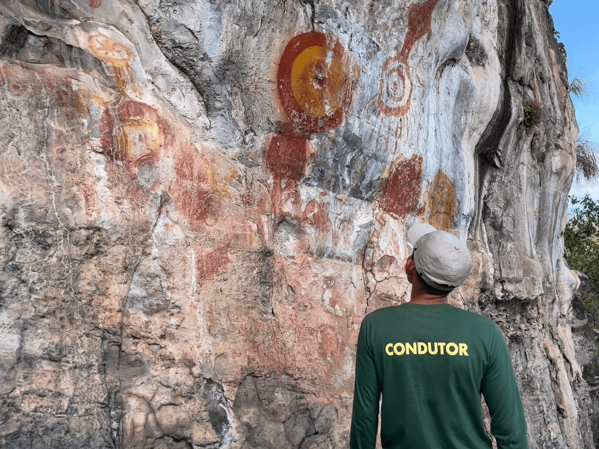
“In addition to the recently publicized Amazonian cities, the region presents hundreds of archaeological sites that prove the population density before the European invasion and the antiquity of human presence in the Amazon. In Monte Alegre, in the west of Pará, excavations carried out in a cave have shown that at least 12,000 years ago indigenous peoples lived in this region and had the technical mastery to make stone artefacts and pigments used to paint on rocks and probably on other perishable substances, such as wood and even their own bodies. The caves of the Carajás mountains have also been occupied for at least 11,000 years by people who mastered the quartz chipping technique for making instruments,” Edithe adds.
Marajoara civilizations had urban organization
Pará has 2,508 archaeological sites registered with the National Historical and Artistic Heritage Institute (IPHAN). One of these was discovered in October 2023 by residents of Vila das Pedras and Laranjal, two communities located in the municipality of Anajás, in the Marajó Archipelago. The findings, indigenous ceramic artefacts that became exposed in the region as a consequence of the drought, and anthropogenic elevations - called ‘tesos’ - indicate that the ancient inhabitants of the place erected buildings which required engineering expertise, knowledge of the land, environment and water regime. The survey of the material was carried out by Goeldi and also points to the formation of regional settlement systems, with social and urban organization for the development of day-to-day activities.
The investigation was a joint action with Iphan. Helena Lima, archaeologist and researcher at the museum, points out that these Marajoara civilizations, as well as those from Ecuador, were interconnected and developed a system of exchanges that advanced through the rivers and streams of the region According to the studies, the society was sophisticated and made use of the environment in such a way that it was possible to generate the biodiversity seen in the Amazon. "We see societies that have increased biodiversity. It speaks of a people.

Looking at a map of the Marajó area and noticing the connections between these different archaeological sites and the tesos, we perceive a large urban region. Marajó has always stood out when it comes to understanding these ancient peoples, before the European invasion."
Knowledge
“They [the Marajó findings] are configured as unnatural elevations, anthropogenic elevations, that is, elevations that were made by the residents themselves. Regionally, they are known as tesos. The Marajoara's tesos were constructions that required engineering expertise, knowledge of the land, environment and water regime, and we can attest it all in these recently registered archaeological sites. So we are talking about many communities or even cities, we could say, connected regionally. On one side of the river, on the other side of the river, into the streams. They are systems with many connected settlements . This shows an organized society, where meetings and exchanges were taking place," adds Helena.
Climate change hinders preservation
The Marajó region has been researched for decades. The findings help researchers tell the local stories, which date back more than 3,000 years. Among the findings, Helena Lima says that many funeral urns have been identified. However, climate change is becoming an obstacle to the preservation of the archaeological site of Anajás and the artifacts found there. "These funerary urns are at risk, as they are right on the bend of a river, close to the town center, and boats are passing by," says Helena Lima…”The erosion of the fluvial regime is exposing these funerary urns, and objects that we suppose being funerary. Respect and care must be even greater with these ancestral items from the region of Anajás," explains the archaeologist.

The challenges encountered go even further. Helena reports that the development of the research in the region has faced several difficulties, demanding high volumes of financial resources. "The community wanted the pieces to remain in Anajás and claimed for a preservation space, an exhibition locus, a museum, a house of culture to be created there. And I see in this desire of the population a great opportunity to work with the communities to build a space of culture and memory for the people of Anajás. We intend to build together with the residents and not, as history itself has carried over time, withdrawing or deleting this knowledge. On the contrary, we want to build on-site, together with the communities," says researcher Helena Lima.
Geoprocessing helped in site mapping
The technology used in Anajás, by Goeldi Museum, to map the cities lost in the forest was the same used in Ecuador - the Lidar. This geoprocessing system is capable of modelling the surface of the terrain in three-dimensional form and relies on the support of other structures, such as boats, to be operated. Goeldi uses a drone. Nilson Borges, a technician who operates the equipment during the visits made to the Museum, explains that the mapping identifies the topological interests of an area and the possible existence of archaeological sites.

"Lidar goes over the area, emitting laser pulses into the environment bouncing off objects and returning to the sensor to form a common RGB image and creating a point cloud. As there are millions and millions of points, we work with both cameras together," he details.
The files collected by the technology undergo processing. This phase can take months before you get an answer that identifies the object of interest for the researchers. In the case of the material inspected in Anajás, the results are not yet ready. “The Lidar emits signals, pulses, and these pulses reach back to Lidar. So, it makes a three-dimensional terrain, according to speed programming, height... The purpose of the research itself. The equipment goes over the ground and vegetation and emits a million pulses, then, we can work on what it can capture, through 3D, and render the products after post-processing of the point clouds," explains Nilson.
Archaeological sites of Pará and the history of ancient civilizations
The state of Pará has more than 2,500 archaeological sites registered with IPHAN. Some regions stand out in terms of the importance of the history analyzed, according to archaeologists from the Emílio Goeldi Museum of Pará.
- Monte Alegre
Studies show that indigenous peoples lived in the region at least 12,000 years ago. They had the technical mastery for making stone artefacts and pigments used for painting rocks, and probably on other perishable surfaces, such as wood and even their own bodies.
- Marajó Island
Recent discoveries in Anajás indicate that the former inhabitants had engineering knowledge to deal with the environment and the region's water regime. They may have lived in the region about 3,000 years ago. The first findings were ceramic and, after inspection, tesos Marajoaras - anthropogenic elevations - were identified.
- Santarém
The Santarém region concentrates archaeological sites with important discoveries about the past. The Tapajós, for example, had been present at the site for 1,300 years, but many other older inhabitants left traces in the city. So far, a study by Goeldi Museum, in partnership with the Universidade Federal do Oeste do Pará (Ufopa), indicates that the presence of Sambaquieiros peoples dates back 8,000 years.
- Salgado Paraense
In Bragança, researchers identified a ceramic archaeological site in the Caeté-Taperuçu Marine Extractive Reserve. With the studies on the area, presented by Goeldi and the Universidade Federal do Pará (UFPA), researchers identified an occupation dating at least 2,900 years. The analyses also point to two hypotheses about the community's way of life. The first concerns cultural exchanges, and the second mentions economic shifts towards cultivation.
- Carajás
The region was occupied at least 11,000 years ago by people who mastered the technique of chipping quartz to make tools. Along the Amazon rivers, Goeldi states that it is common to find sites with black soil, where pottery fragments abound. These places correspond to ancient indigenous villages.